
Elon Musk’s prophecy of a solar-powered civilization is coming to pass as we see a significant rise in the demand for solar panel installations. The increasing interest in eco-friendly electricity generation, along with government subsidies and cost-saving opportunities, has pushed people towards choosing renewable energy.
The solar surveying industry is on the rise in the US, as it plays a crucial role in the installation process of solar systems. According to a recent S&P Global market insights article, the solar industry is all set to dominate the world of green energy. Surveying is crucial to determine the optimal location for solar panels to achieve maximum efficiency.
Solar surveying helps
- Determine viability and feasibility
- Analyze the local climatic conditions
- Fulfill the customer’s energy needs
- Identify any shading on the roof
In 2020, the worldwide digital twin market size was valued at $3.1 B, and by 2026, it’s expected to reach $48.2 B. As the demand for solar grows, businesses are shifting from traditional surveying methods to advanced technology that expedites the process. Each method has its own set of strengths and weaknesses, let us take a deeper look into the benefits and limitations of solar surveying methods.
“Drones are a game-changer for solar installers, which replace ladders, measuring tapes, and hand-drawn roof surveys with a quick drone flight, which is safer and ten times more accurate,” says Winn, CEO of DroneDeploy.
Traditional methods of solar surveying
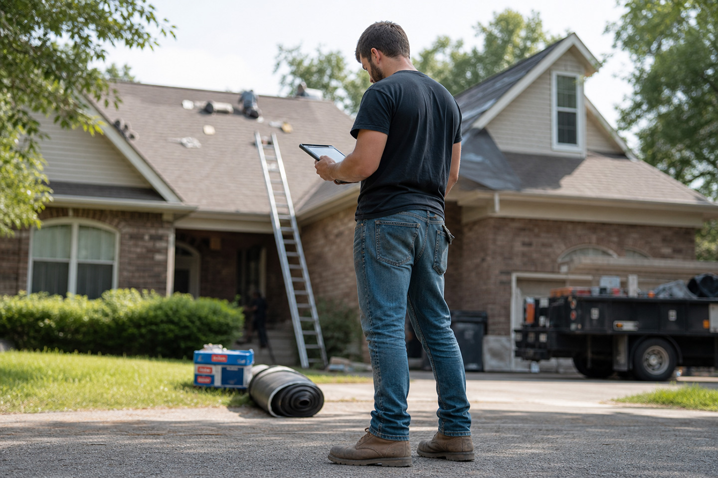
Solar surveying is an on-site process that involves collecting crucial pieces of information for efficient solar panel installation. In the conventional method, a professional must climb onto roofs and collect data based on the movement of the sun and light absorption. While they lacked technological assistance, their expertise helped them to complete the surveying process on time.
The traditional surveying methods are
- Shadow and stick method
- Sun path diagram
- Theodolite, and clinometer
The shadow and stick method is the most basic way of identifying cardinal directions. A stick is planted in the center, and the shadow it makes is observed and noted for about 15 minutes. The direction of the shadow determines the position of the sun.
The sun path diagram draws out the angle of the slope, which determines the location that can absorb the most light. In this method, angles and distances on the survey site are marked by the surveyor. It is then plotted on a map manually to identify the location most suitable for panel installation.
Likewise, the theodolite and clinometer methods also calculate the azimuth angle to determine the sunlight intensity in the area. But, there are more sophisticated techniques than the sun path diagram because both are optical instruments that are lightweight and easy to use.
Benefits
- Cost-effective
- Easy to use
- Simpler data
As evident, traditional methods of solar surveying are easy to use and cost-effective. They don’t require software and need no training. Hence, it becomes effortless to do the procedure and collect data for solar installation.
Limitations
- Prone to manual errors
- Lack of in-depth data for analysis
- Consumes a lot of time
Since the traditional method does not utilize digital tools, they are prone to manual errors. At the same time, manually measuring the surface takes a long time, and the resulting data lacks in-depth details.
Use of technology in solar surveying
The increasing demand for solar panels is one of the driving forces for adopting modern surveying technologies. It is undeniable that the role of technology in surveying has changed the course of the solar industry. Two of the current technological trends in solar surveying are:
- Google Sensors
- Drone – LiDAR and Photogrammetry
Google sensors
The Google sensors come with tilt sensors, a camera, and a compass. The sensors detect and analyze the topography by sensing the emitted radiation traveling back and forth. Sensors allow tracking of the clouds in the area to predict possible climatic conditions.
The camera brings out a larger picture for analysis. It gathers pictures and helps spot shadowing and overlapping obstacles in the sun’s path. The compass enhances the process, indicating the path that receives the most sunlight. Using this information, a surveying report is calculated, which can determine if a location is suitable for solar installation.
Drones
Let’s talk about drones now!
Drones are versatile in the use of aerial images and digital spatial models. Drone technology is an efficient method to conduct solar surveying without the need for manpower. It only requires a drone pilot. There are various types of drones, including LiDAR and Photogrammetry. In the future, there may be even more advanced drones as the technology continues to evolve. As of now, the drones helping perform solar surveying today use LiDAR and Photogrammetry.

Photogrammetry
In simpler terms, Photogrammetry is a solar surveying method in which drones are used to take multiple photographs and these photographs are turned into a 3D model using a separate software package. Next, the measurements are processed and an accurate data model is produced.
Light Detect and Ranging (LiDAR)
Light Detect and Ranging (LiDAR) drones generate unmanned aerial data from multiple vantage points to create a topographic image. Laser beams are used to achieve it. The laser beams sent from the drones strike the ground and bounce back. The time taken for the laser to return is noted and becomes part of an accurate data model.
LiDAR drone technology is more efficient and accurate than Photogrammetry because LiDAR drones have high-resolution cameras and use Global Navigation Satellite System (GNSS) to extract precise data.
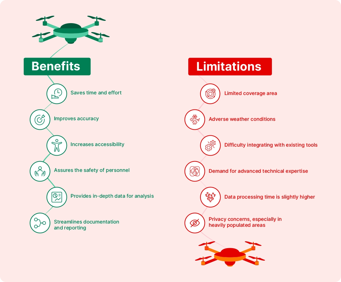
Benefits
Solar surveying using advanced technology assures two things. First, it allows work to be completed in a few hours instead of a week or two as in the traditional method. Second, it assures the safety of personnel, while the traditional solar surveying method puts them at risk when climbing on rooftops.
Drones generate accurate measurements and precise data. Additionally, photos taken by drones are embedded with fine details, such as geotagging and data regarding the optics used. This information is processed for in-depth data analysis.
Limitations
Cost is an important factor, and we cannot ignore it when considering what technology to adopt. The expense of incorporating technology into the process of solar surveying is high. Despite the depth of data that a drone can provide, understanding it requires effort.
The pilot needs special training to use it properly and has the difficult task of determining the correct altitude to fly the drone. And, if the camera quality is poor, then you may be left with erroneous data. Weather conditions can influence the data quality. For instance, if the solar survey is taken on a day when the weather is bad, the collected data could be unreliable.
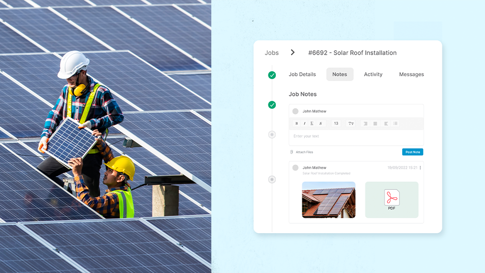
Simplify site inspection with a single drone operator
instead of dispatching several workers to a site, you send one person to fly a drone. The drone will capture comprehensive images and create a digital twin of the site. You can then share this precise digital model with your entire team, enabling seamless review and collaboration from different locations. This approach not only conserves time and resources but also provides a single, reliable “source of truth” for your documentation needs. By leveraging drone technology, you streamline your workflow and improve the accuracy and efficiency of your site inspections.
Conclusion
We must acknowledge that technology has a significant effect on the solar surveying process. Even though adopting advanced technology demands considerable investment upfront, we cannot forget that using it saves a lot of time and money for the solar business. Benefits such as safety, accessibility, accuracy, and analytics, transform the workflow and improve efficiency.
However, both traditional and conventional technology has both merits and drawbacks. Some prefer accurate methods; some prefer cost-effective methods and some prefer methods that save time. Knowing your options will allow you to choose the surveying method that suits your business needs and streamlines your solar operations.
Get insider access! Join our community and receive exclusive insights on the future of solar technology and best practices.